Activity
Mon
Wed
Fri
Sun
Jan
Feb
Mar
Apr
May
Jun
Jul
Aug
Sep
Oct
Nov
What is this?
Less
More
Memberships
Your Land Is Gold
16 members • Free
34 contributions to Your Land Is Gold

Oct 11 •
Due Diligence planning (Conversation with the County)
I'm assuming we're going to get to an agreement on my preferred land purchase so I'm looking at what's ahead so We can get everything done in the 60 days I requested. I'd appreciate your feedback back on the conversations with the County and Dept of Natural Resources. Here's everyrhing I have on my list. Am I missing anything? Must Do: - Perc test for septic system (simple task) - Engineering evaluation of the dam (simple task) - Contact the county to get a better understanding of their requirements (need advice) - Contact DNR, ACoE, etc about wetlands (need advice) - Order a site plan - Meet with insurance providers Might Do: - Schedule a meeting with local Chamber of Commerce - Visit the neighbors - Build a topographic map to help me plan - Build a Social Media plan - Evaluate my IT stack options

1 like • 17d
@Anja Wynne what booking platforms do you/will you be using?

Oct 11 •
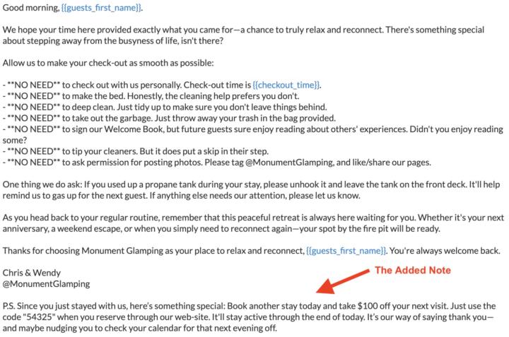
A Little Trick I Picked Up at the Glamping Show
At the Glamping Show Americas, I learned a clever little retention tactic that I’m testing right now with our guests. When someone checks out, I send them a warm farewell message—everything from checkout details to a genuine thank-you for choosing Monument Glamping. But at the bottom, I’ve added a same-day incentive: a $100 coupon code if they book their next stay before midnight. It’s simple, friendly, and might just turn a one-time stay into a returning guest. I’ll share the actual results—conversion numbers and all—once I have them.Remind me in our next meeting to bring that data; I’m curious to see how well it works in practice.
1 like • 17d
what a great idea!!!
Oct 11 •
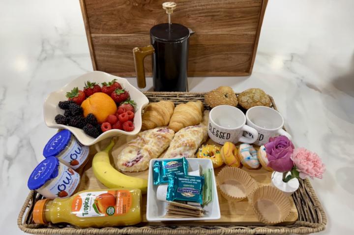
Man, I Love This!
This morning I made one of our King’s Breakfasts for a guest—eggs, fresh fruit, a muffin, yogurt, hot water for tea, and a full thermos of locally roasted coffee from Serrano’s. It looked beautiful sitting in the basket. We charge $59, which honestly feels like a steal considering the joy I get out of making it. There’s something about handing that breakfast off, still steaming, that just feels right. Here’s the automatic note that goes out through iGMS right before I walk it down to the tent: -- Hi Megan, I’ll be delivering your breakfast in a few minutes. I’ll leave the container and thermoses on your porch. A few other details: 1. The coffee is locally brewed from Serrano’s. 2. All the fruit has been washed—no need to rinse. 3. When you’re finished, just place all the dirty dishes and leftovers back into the container. We absolutely love making breakfast for our guests, and we’re so glad you chose the King’s Breakfast! —Chris & Wendy
0 likes • 17d
Chris do you have any egg/protein choices and if so what kind of egg choices?
Oct 8 •
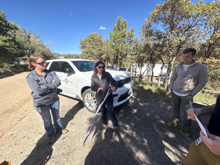
County Walk Update — HUGE Win for Monument Glamping!
We had our county walk today with the Planning Department. What was supposed to be a quick visit turned into nearly an hour of hashing out boundaries and definitions — literally. We walked down to King’s Quarters and spent most of the time arguing over where the property line actually sits, whether the tent is truly a tent, and how to map out every foot of the site. This time, though, we had the Planning Director himself with us instead of just the enforcement officer calling the shots. The enforcement officer was still stubborn about how exact the map needed to be. Even though he couldn’t prove the boundary, he kept insisting I was within it by about 10 feet. His claim came from OnX, and when I pointed out that OnX could be off, he said, “Well, not by 10 feet.” I asked, “Then how many?” He didn’t know. That’s when the Planning Director stepped in and said, basically, “Let’s not waste taxpayer money on a survey.” His solution: get stakes in the ground, mark it clearly, and the county will work from there. No neighbor complaints, so just make it 25 feet back and move on. He also clarified that our site map needs to change — instead of each tent being a 16x16 box, we’ll represent them as 60x60-foot lots, and make sure each tent sits correctly inside. Here’s where the good news gets better: the Floodplain Administrator reviewed photos of King’s Quarters and confirmed that it’s a soft-sided structure — a tent, not a building. That same finding could end up clearing my Building Department violation too, since it’s based on the same misunderstanding. So, in short — we walked away with a path to full compliance. The boundaries are set, the map is being redrawn, and the tent issue looks to be resolved across both departments. It’s been a long road, but this meeting finally felt like progress. [I read this post to Wendy, and she added: "Now we can build all our tents just like King's Quarters!"]
1 like • 17d
what a way to be a trailblazer!! Great Job!!

Oct 8 •
One final option, last post
I have access to this high end thermally modified vertical wood siding. Here is some renders of some available options, is this a big step up from the James Hardie siding pics I posted earlier. and which one calls out to you, ignore the door color.

0 likes • 17d
The dark one for sure!! I know I'm way behind on these posts
1-10 of 34

@kelli-boehning-8573
I live in Penn Run PA on 98 acres of land that I intend on starting up a Glamping business.
Active 17d ago
Joined Sep 6, 2025
Penn Run Pennsylvania
Powered by