
Write something
Mar 22 •
European Trail Marking Systems
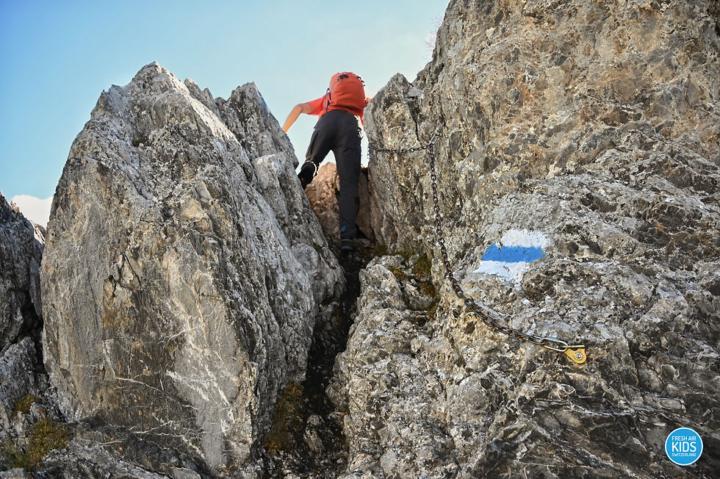
The European trail marking system provides a standardized visual language for hikers, primarily categorized by distance and administrative scope across countries like France, Spain, and Italy. The most prominent indicators are the red-and-white horizontal stripes, which signify GR (Grande Randonnée, Gran Recorrido, or Grande Escursione) routes—long-distance paths that often traverse entire mountain ranges or cross international borders. Complementing these are the yellow-and-white marks for PR (Petite Randonnée or Pequeño Recorrido), representing shorter day-hikes, and green-and-white stripes for SL (Senda Local) paths, which designate brief local circuits often under ten kilometers. In addition to simple bars, a "cross" of the same colors indicates a wrong turn, while an "angle" denotes a change in direction, ensuring clarity throughout the navigation process. While this tricolor system is widely adopted, regional variations exist to address specific safety requirements and historical traditions. In Italy, the Club Alpino Italiano (CAI) frequently utilizes a distinct red-white-red horizontal band, often featuring a black identification number in the center to help hikers cross-reference their exact position with official maps. Moving into the central Alps, countries like Switzerland and Austria utilize a more granular approach: yellow signs or diamonds indicate general hiking trails suitable for standard footwear, whereas white-red-white markings warn of challenging mountain terrain where surefootedness and mountain boots are required. For the most demanding routes, white-blue-white markers signify technical alpine paths that may involve glaciers or steep rock scrambles. This layered system of symbols serves as a critical safety framework, allowing hikers to interpret the difficulty and direction of a trail at a single glance.
0
0
Oct '25 •
Paper Maps
While our phones and GPS devices are undeniably useful, I wanted to put in a strong word for a piece of essential gear that should never leave your backpack: the good old paper map. In the mountains, especially in Spain's big ranges, battery life can be fleeting, and signal is often non-existent. A detailed, durable paper map is the only truly reliable backup and the best way to maintain situational awareness. Nothing beats laying out a map to visualize the terrain, upcoming challenges, and potential bail-out routes. In my experience, when hiking the two great areas we've discussed, there are two map producers that stand out: 1. Editorial Alpina: For comprehensive coverage of the high mountains, Editorial Alpina makes, in my opinion, the gold standard for maps of the Pyrenees and Picos de Europa. They offer excellent detail, including hiking paths, refuges, and topographical information. They cover the entirety of those ranges, with perhaps around two dozen maps needed to cover the whole network of routes. If you're tackling any serious multi-day trek in the Pyrenees, these are the ones to get. 2. Local Specialists: However, if you are focusing on a specific region, you can sometimes find even better local cartography. For example, in the Valencian Community, maps produced by el Tossal Cartografies are truly outstanding. They often feature an incredible level of trail detail and local knowledge that sometimes surpasses even Alpina's, though their coverage is limited to that specific area.
0
0
Oct '25 •
Trail Marking in Spain
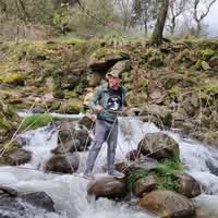
Knowing the trail markings in Spain is essential for a safe and enjoyable hike, as they tell you not just the way, but also the type of trail you're on. The main system for marking hiking trails across Spain (and other countries in Europe, like France) uses a combination of two horizontal color stripes, called "blazes," painted on rocks, trees, or posts. The colors indicate the category and length of the route: The Trail Blaze Code Blaze (Stripe Colors): White over Red - GR (Gran Recorrido - Long Distance). Long-distance routes, typically over 50 km, requiring multiple days or weeks (like the GR-11 in the Pyrenees). White over Yellow - PR (Pequeño Recorrido - Short Distance). Shorter routes, typically between 10 km and 50 km, manageable in one or two days. White over Green - SL (Sendero Local - Local Trail). Very short routes, usually under 10 km, often circular, and great for a quick, easy outing. How to Follow the Blazes The shape of the painted blaze tells you what to do at a junction or point of interest: Two parallel stripes - You are on the correct path. Keep going straight. An angle or V-shape - Direction Change. The trail makes an abrupt turn. Follow the direction of the angle. (e.g., if the stripes turn right, you turn right). An X or crossed stripes - Wrong Way. Do NOT follow this path. You may see this near a junction to indicate the path that is not the designated route. Turn back to the last correct marker and find the proper direction. Important Notes - White is Key: Notice that the white stripe is always the top stripe in this official system, with the colored stripe below it. - Camino de Santiago Exception: The famous Camino de Santiago routes often use their own distinct markers, primarily a Yellow Arrow or the Scallop Shell (Concha), rather than the red/yellow/green blazes. If you are hiking the Camino, stick to those unique markers. - Other Blazes: In some areas, you may see single color dots or stripes (like just a blue dot) which can indicate variants, local routes, or even a system used for mountain biking, but the white/color stripe system is the most standardized for hiking.
0
0
Oct '25 •
Introduction
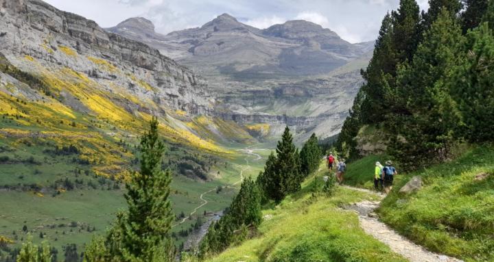
Hello everyone! I'm excited to start this community of hikers and share some thoughts on what makes Spain such an incredible destination for outdoors activities. In my view, when it comes to the summer season, there are two areas that stand head and shoulders above the rest: the magnificent Pyrenees, and the rugged, breathtaking Picos de Europa. These offer high-mountain challenges and spectacular scenery that are truly world-class. Of course, Spain has a wealth of other fantastic, albeit smaller, hiking areas scattered across the country, each with its own unique charm, more on each one of those later. When the snow starts to fall in the big mountains, my preference shifts towards the southern and eastern parts of the country. For the winter season, you simply can't beat staying close to the Mediterranean. The weather here is wonderfully mild—you can often enjoy fantastic, sunny days on the trails, sometimes even hiking comfortably in shorts and a T-shirt in the middle of January! Looking forward to sharing experiences and getting some great recommendations from you all! Happy hiking!
0
0
1-4 of 4
powered by
skool.com/hiking-in-spain-6512
Everything about hiking in Europe - from learning to navigate the trails and essential maps to trail recommendations all around the country.
Suggested communities
Powered by