
Write something

Oct 21 •
Good morning All,
It’s your girl, sending you love, support and encouragement today. No matter what- keep going, keep believing in yourself, your dreams and your goals! Everything you seek (positive) is seeking you too! If you have a challenge that you need deeper support on, comment below! 👇I got your back!

Sep 30 •
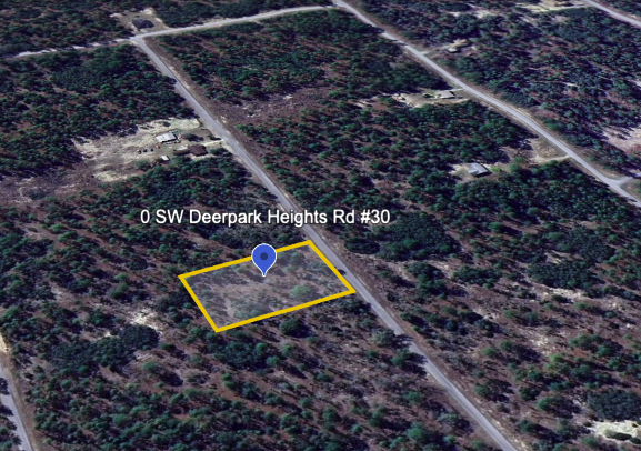
Tools I Use to Market Properties After I Buy Them 🏡
Buying at auction is only half the game—the other half is knowing how to get eyes on your property once you own it. Here are the tools I use (all free) to make that happen: 🛰️ Google Earth – I pull clean aerial shots so buyers can see exactly where the property sits, plus any nearby roads or features. 📸 Historic Aerials – This one’s cool because it shows how the area has changed over time. If development is creeping closer, that makes your land way more appealing. 🗺️ Google Maps – Buyers love exploring the area. I always link maps so they can click around and check schools, grocery stores, highways—all the stuff people care about. 🌐 County GIS Map – This is the real gem. It gives you zoning, lot lines, and even flood zones straight from the county. It not only helps me with due diligence, but it also gives buyers peace of mind. 🏡 Zillow – Little tip here: don’t overcomplicate it. Peek at how other properties nearby are being marketed. Take notes, borrow the structure, and then make your listing stand out with better pics or a cleaner description. No need to reinvent the wheel. 😉 👉🏽 The thing is, all of this is free—you’re just trading time. And sometimes, that time adds up. That’s why I’ll also use a realtor on certain deals. They’ll do the heavy lifting, throw it on the MLS, and usually get me more exposure (and sometimes a better price). Yes, they take a cut, but sometimes speed and convenience are worth it. 💡 Truth is: this strategy works. Whether you’re DIY’ing it with these tools or handing it off to a pro, the point is simple—marketing is what turns your auction win into actual profit. 🚨 CTA: Want the full breakdown of how I market, sell, and flip these properties? Come join the Elite Community. We’ve only got a few spots left before September closes, and you can still grab $50 off with promo code "LANDGRABBLITZ". 👉🏽 Join here: redlotusprep.com/join
Sep 18 •
🚨 PA Tax Sale Gem Alert 🚨
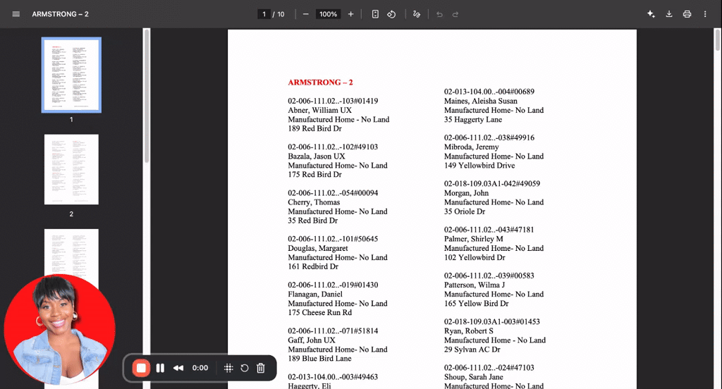
I was digging into Indiana County, Pennsylvania this week and stumbled on something too good not to share. The county just had their upset sale, but here’s the kicker: everything that didn’t sell is about to roll onto the repository list. And y’all… that list is STACKED. 👉 Pages of inventory. 👉 Mobile homes. 👉 Small vacant plots — half an acre here, .30 acres there. 👉 Opening bids starting at just $1,000. Now imagine this: you scoop up a half-acre lot, grab one of those manufactured homes, and—if zoning lines up—you’ve just created an instant cash-flow play. That’s land + housing at entry-level prices most people don’t even know exist. This is why I keep saying PA is an interesting state for investors: - Repository / OTC sales = less competition, direct purchase options. - Low entry bids = big upside if you do the research. - Inventory variety = mobile homes, land, and more. But here’s the thing: a list of properties is just step one. What really matters is knowing which ones are worth your money. Some of these deals are goldmines. Others? Straight landmines. 💡 That’s where the analysis comes in. In the paid community, I break down deals with you: - How to run the numbers. - How to spot red flags before you spend a dime. - How to build a strategy around properties like this in PA (and beyond). So if you want me in your corner while you’re combing through lists like this, it’s time to upgrade. Let’s take you from “this looks interesting” → to “I just bought a $1,000 property that’s making me money.” Drop a 🔑 if you’re ready to unlock this strategy, and I’ll show you how to get in. Im giving $50/month (every month) to the next 20 ppl who sign up!

May 21 •
It’s time to choose you
Blood is NOT thicker than your peace, so if anything or anyone is disturbing your peace exit stage left with fuss, frown or argument because it’s God telling you it’s time to let go and let Him.
May 28 •
HELLO ALL
So nice to meet like minded people on this platform, thank you all for having me. One of the things I would like to share is and ask is how many of us here have businesses and have had businesses, but feels like our circle is so small that no one or very few will participate and support what we are offering. We forget the world is bigger than our immediate circle? I am that person so being in this environment I hope will help me to exam mind, thinking, and circle. I own photobooth a, I am a travel agent looking for others to partner and make passive and more income while building a team and money while they sleep in many many ways with travel. I live in Katy, TX. Thanks for allowing me this platform to share.
1-9 of 9

skool.com/red-lotus-prep-free
A free community to learn tax-defaulted property investing, credit repair, and business credit building while connecting and growing together! 💳🏡 🪷
Leaderboard (30-day)
1

+2
2

+2
3

+1
4
+1
5

+1
Powered by