
Write something
17h •
SF/Bay Area — Explore The Field — Trip Mode
Welcome to XploreForge LLC — Explore The Field SF/Bay Area field drops land here. Want to be featured as a Contributor on a Forge Field Notes Planning Guide? 1. Two images — panoramic or 16:9. 2. One "made me stop" line. The moment, not the recap. That's it. Poke around the community. Reach out if you have questions. The solitude is out there waiting. Go find it.
2d •
Summit OS V2.0 — Coming Soon — Book My Trip — Trip Mode Node
Okay this is getting silly check out the "Book My Trip" feature It gives you the "How are you traveling options" —👇 How are you showing up to this one? 1. RV / Van⏎ 2. Tent Camp 3. Hotel / Inn 4. Sleep in the Car 5. Cabin / Glamping 6. Bike Touring ======================================= RV/Glamping : Critical data point: Big Meadow is currently closed and sits at 6,400 ft — likely still under snow in early May. That's too high for an early May RV trip. I need to identify lower-elevation options closer to Arnold that can actually accommodate an RV on May 1–3. Good. Wa Ka Luu Hep Yoo is the move — RVs up to 50 feet, river access, first-come first-served, opens May, $35/night in 2026, no hookups. Big Meadow is closed and too high for early May. Dispersed camping is permitted on the Calaveras Ranger District on non-wilderness USFS land. I have everything I need. RV / VAN · ARNOLD, CALIFORNIA · MAY 1–3, 2026 STEP 1 — USFS DISPERSED CAMPING · Calaveras Ranger District Dispersed camping is generally permitted on Stanislaus National Forest land within the Calaveras Ranger District on non-wilderness, non-developed areas. The honest field note: forest roads in this corridor are mixed — some paved, some dirt, some recovering from the early April storm that downed trees on the ART. Early May access on dirt forest roads is uncertain after a wet winter. Do not commit a rig to a forest road without confirming current surface conditions and vehicle length restrictions with the ranger district directly. Calaveras Ranger District: (209) 795-1381 · Monday–Friday 8:30 AM–4:00 PM Campfire permit required for any fire outside a developed site: readyforwildfire.org/permits 14-day stay rule applies. Current fire restrictions: verify at fs.usda.gov/stanislaus before arrival. STEP 3 — DEVELOPED USFS CAMPGROUND Wa Ka Luu Hep Yoo (Wild River) Campground — Sourgrass Recreation Area This is the best RV base camp for this trip. 49 sites on the North Fork Stanislaus River, mature conifer and oak forest, flush toilets and showers on site. RVs up to 50 feet accommodated — access road is confirmed manageable for rigs, no tight turns reported. First-come, first-served. No hookups — no electric, no water, no sewer connections. $35/night in 2026. America the Beautiful pass gets 50% off.
2
0
8d •
Trip Mode - Bodega Update - Morning Field Actions
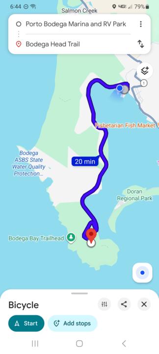
TRIP MODE · BODEGA BAY · APRIL 23–26, 2026 Sonoma Coast · 4-day field brief Today is Friday - We arrived Thursday mid day and missed the Morning Field Action so I am going to attempt to get both of these in today. Bodega Head Loop Trail is a 10-15 min. E-bike (RadRover St) ride from the Porto Bodega RV park, we only booked here with friends to celebrate a birthday but there are plenty of less expensive options if you are up to camping or dry camping. The FFN Planning Guide protocol produced a complete 4 day list of morning and evening opportunities to capture different experiences during our stay. You can read the beginning stages below: The report includes ecological, flora, astrology nodes, sunset and sunset info. The Kortum Trail North is approximately a 35 minute bike ride or 6.5 miles on HWY 1 North from the rv park to the trail head so we'll see if I make that ride today or maybe we can get someone in the group to drive up? I am documenting not only for the experiences but also to validate or debunk my Ai protocols as to it's accuracy. When I subjectively fact checked the information it comes up as highly accurate... I did not map these locations prior to our trip but attached you will see bike mapping, keep in mind the maps do not take into account e-bike. ECOLOGICAL HEADLINE Late April on the Sonoma Coast is a convergence window. Pacific gray whale northward migration is winding down — stragglers and mother-calf pairs push through the corridor just offshore into late April, and Bodega Head gives you an unobstructed sightline into that lane. Simultaneously, the coastal scrub is mid-bloom: sticky monkey flower, lizardtail, and coastal bush lupine are peaking on the headlands. Shorebird staging is active — the mudflats at Bodega Harbor pull in whimbrel and dunlin moving north. The ocean upwelling cycle is strengthening this time of year, which is why you'll see more bird activity over the water than you expect. This is not a quiet week on the coast. Moon phase late April 2026: waning gibbous moving toward last quarter — still significant light early in the window, darkening by the 25th–26th. Front-load any dark-sky work toward the end of the trip.
9d •
Forge Field Research - Trip Mode
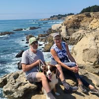
First official trip since starting "Explore The Field" community group. We are off to Bodega Bay California to gather first hand in the Field raw data, below is what the Summit OS protocol produced for us in "Trip Mode" now we have a bases of what to expect. Enjoy my little trip launch video. We will see just how accurate the FFN Planning card is, so here you go: TRIP MODE · BODEGA BAY · APRIL 23–26, 2026 **Sonoma Coast · 4-day field brief** --- ## ECOLOGICAL HEADLINE Late April on the Sonoma Coast is a convergence window. Pacific gray whale northward migration is winding down — stragglers and mother-calf pairs push through the corridor just offshore into late April, and Bodega Head gives you an unobstructed sightline into that lane. Simultaneously, the coastal scrub is mid-bloom: sticky monkey flower, lizardtail, and coastal bush lupine are peaking on the headlands. Shorebird staging is active — the mudflats at Bodega Harbor pull in whimbrel and dunlin moving north. The ocean upwelling cycle is strengthening this time of year, which is why you'll see more bird activity over the water than you expect. This is not a quiet week on the coast. Moon phase late April 2026: waning gibbous moving toward last quarter — still significant light early in the window, darkening by the 25th–26th. Front-load any dark-sky work toward the end of the trip. --- ## MORNING FIELD ACTIONS **Thursday April 24 — Bodega Head Loop** Out from the Bodega Head parking area, full headland circuit. The western bluff edge is your whale watch position — spend your deliberate stop there facing northwest. ≈ 4,500–5,000 steps · ≈ 2.5 mi · allow your full 60-minute window **Friday April 25 — Kortum Trail North** Pick up the Kortum Trail from Salmon Creek Beach northward along the bluff. The trail runs open coastal terrace — no tree cover, full exposure to the marine layer burn-off if it happens. Turn at your time limit. ≈ 4,500–5,000 steps · ≈ 2.5 mi · 60-minute window, out-and-back **Saturday April 26 — Doran Regional Park Beach Walk + Spit**
2
0

1-4 of 4
powered by
skool.com/explore-the-field-8042
Nature-powered field protocols for burned-out professionals. Real trails. Real geology. Your AI delivers the signal daily once Setup @XploreForge LLC
Suggested communities
Powered by