Activity
Mon
Wed
Fri
Sun
Jul
Aug
Sep
Oct
Nov
Dec
Jan
Feb
Mar
Apr
May
What is this?
Less
More
Memberships
TheStreetarckitect
143 members • Free
Daily Sales Jobs
3.4k members • Free
AI Automation First Client
1.8k members • Free
ArchiBIM Academy
2.4k members • Free
Synthesizer: Free Skool Growth
42.4k members • Free
New Apps & Groups for Earning
450 members • Free
AI Automation Society
393.4k members • Free
Digital Builders
73 members • Free
3 contributions to Digital Builders

25d •
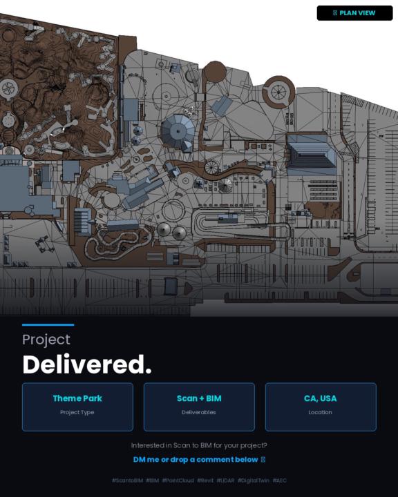
Millions of Points. One Clean Model.
A theme park in California — fully documented from raw point cloud to a complete Revit BIM model. Every ride, structure, path, utility line, and site element modeled. The kind of project where the scan data alone runs into the hundreds of millions of points, and the challenge is turning that chaos into something a contractor or architect can actually use. 360° scan coverage. Full site. Delivered.
1
0
25d •
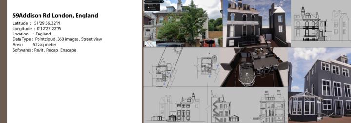
From Point Cloud to Revit — London Victorian Residence
📍 59 Addison Rd, London, England Victorian-era residential property — 522 sqm of complex geometry, multiple rooflines, bay windows, and a rear conservatory extension. Not the easiest scan-to-BIM job, but that's exactly what makes it interesting. Data captured via point cloud + 360 imagery + street view references, then processed through ReCap and modeled in Revit from ground up — floor plans, all four elevations, sections, and a full 3D model rendered in Enscape. The challenge with older UK properties like this one is the irregularity — nothing is perfectly plumb or square, and the scan data tells you that immediately. The model has to reflect reality, not idealize it. Coordinates: 51°29'56.32"N, 0°12'27.22"W Tools: Revit · ReCap · Enscape #ScantoBIM #PointCloud #Revit #RealityCapture #BIM #LondonArchitecture #AsBuilt #Enscape #ArchitecturalDocumentation #LIDAR
0
0
26d •
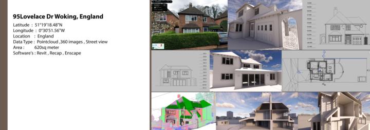
As-built Revit model and Drawings !
🏡 95 Lovelace Dr, Woking, England | Scan to BIM From point cloud to a fully detailed Revit model — here's a complete residential Scan to BIM project delivered for a property in England. 📍 Location: Woking, England 📐 Area: 620 sqm 🔧 Data Type: Point Cloud + 360 Images + Street View 💻 Software: Revit | ReCap | Enscape What we delivered: ✅ Accurate 3D Revit model from point cloud ✅ Architectural floor plans & sections ✅ Elevations with precise dimensions ✅ Enscape renders for visual presentation ✅ Full exterior & interior geometry captured Whether you have scan data or just 360 images — we convert it into a clean, accurate BIM model ready for design or renovation work. 📩 Have a project? Let's talk!
0 likes • 25d
Yes sure .
1-3 of 3